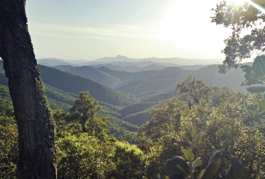
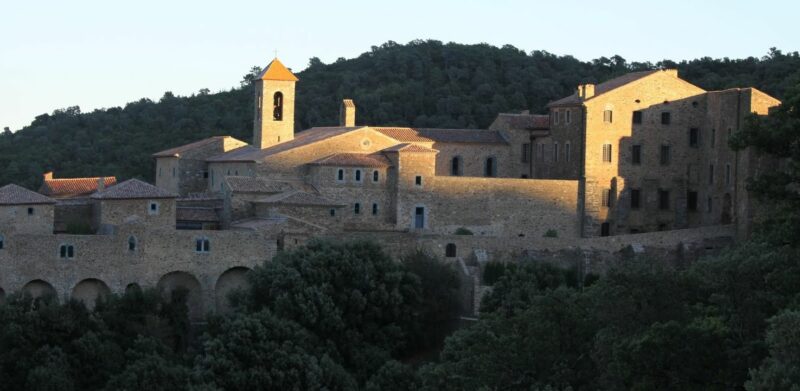
The Verne monastery is a historic religious monument in the Maures national forest.
Built on the site of an abandoned priory already known as Notre Dame de la Verne, the Chartreuse was founded in 1170 on the initiative of Pierre Isnard, bishop of Toulon, and Frédol d'Anduse, bishop of Fréjus.
Successive fires in the 13th, 14th and 16th centuries ravaged the monastery, destroying all its buildings. It was rebuilt each time. The most recent reconstruction took a long time, and was scarcely completed when the French Revolution broke out, leading to the sequestration of all property. In 1792, after the last Carthusian monks had fled, the land, buildings and furnishings (religious objects, paintings, library, etc.) were sold as "national property".
On January 18, 1921, the Chartreuse was classified as a historical monument, and on March 1, 1961, the Ministry of Agriculture became the owner. Since 1983, the Chartreuse has been home to the monastic families of Bethlehem, the Assumption of the Virgin and St Bruno.
Access to the building was originally via a monumental serpentine gate to the south, and is now to the left of this gate.
VERY IMPORTANT: From June 21 to September 20, the RD214 road leading to the Chartreuse is subject to the Var forest access regulations, in compliance with the fire risk prevention plan. For further information, please call the Collobrières tourist office on 04 94 48 08 00 or consult the Var prefecture website http://www.var.gouv.fr/ or the daily press (Var Matin).
THE HISTORY OF THE MONASTERY
Built on the site of an abandoned priory already bearing the name Notre Dame de la Verne, the Chartreuse was founded in 1170 on the initiative of Pierre Isnard, bishop of Toulon, and Frédol d'Anduse, bishop of Fréjus.
At the time of the Carthusian monks, the line dividing the dioceses ran through the middle of the church and cloister, i.e. north-south. According to some, the Romanesque church was built on a pagan temple dedicated to the goddess Laverna, protector of thieves who found safe haven in the thick forest of the Maures, and Verna, the Latin word for slave, used to designate the descendants of the Saracens of Fraxinet (La Garde Freinet). Finally, vernium is also used to designate the Alder tree. Indeed, alders are common on the banks of the river flowing at the bottom of the valley. The first Romanesque church was consecrated on October 3, 1174. It was destroyed by fire and rebuilt. Thanks to numerous donations and purchases, the Chartreuse de la Verne soon became the owner of over three thousand hectares of land (forests, pastures, farmland and saltworks). The Charterhouse was burnt down in 1214, 1271 and 1318. The fire destroyed all the buildings except the Romanesque church.
Each time, it rose from the ashes. In addition, the convent came under attack from numerous looters, sometimes from the surrounding lords, but also from the Saracens and, in 1577, during the Wars of Religion. It was probably as a result of this last invasion that the vault of the Romanesque church collapsed. Others claim that the collapse took place between 1707 and 1715, following attacks by the Duke of Savoy's army against Louis XIV's troops during the siege of Toulon. In the minutes of the search of the Chartreuse drawn up by Collobrières municipal officers on June 7, 1790, it is stated that "the old church having been destroyed more than 200 years ago, services are held in a large, well-maintained chapel with a beautiful marble altar and a sanctuary paved with blue and white marble".
Whether rebuilding or continuing the construction program, the Carthusian monks were hardly "idle": the dates 1736 on the access door to the lodgings located to the west of the entrance vault, 1772 on the pediment of the access vault to the church and cloister, 1789 on the "East" pediment of the (West) access vault to the gardens, bear witness to this.
In 1790, however, the Revolution led to the sequestration of all the Carthusian monastery's assets, and in 1792, after the last Carthusian monks were forced to flee, the buildings and grounds were sold as national property. The last prior, Dom Raphaël Paris, fled to Bologna in Italy. Leaving the Carthusian monastery, the Carthusians were able to reach the beach of Saint Clair near Le Lavandou, and from there by fishing boat to Nice, where the bishop of Nice put a wing of his bishopric at their disposal. The religious history of the Chartreuse de la Verne, dedicated to the Virgin "Notre Dame de Clémence", had lasted just over six centuries. This was to mark the beginning of a long period during which nature would take over the site and cause extensive damage to the buildings, sometimes with the help of unscrupulous walkers. By decree of January 18, 1921, the Carthusian monastery was classified as a historic monument, with the exception of the farm buildings and the courtyard of honour they surround. On March 1, 1961, the Eaux et Forêts became les affectataires, on behalf of the estates, and installed a janitor.
At the time, nothing seemed capable of saving the chartreuse from certain disappearance, when in 1968, under the impetus of Mme Annette Englebert and her friend Annick Lemoine, an association called "Les amis de la Verne" came into being and decided to set about renovating the site. Between 1969 and 1982, this dynamic team, with limited means but a great deal of energy and desire, carried out major works that gradually brought the chartreuse out of the oblivion of history. In 1982, La Verne returned to its original vocation, welcoming monks and, from 1986, nuns from the Bethlehem, Assumption of the Virgin and Saint Bruno monastic families. Much more extensive renovation work then began on all the buildings, which saw the rebirth of the Romanesque church and the large cloister. The work was made possible by the combined efforts of the monastic family, the French department of historical monuments, the commune of Collobrières, the association "Les amis de La Verne" and the many visitors who now came to La Verne, some of whom became true patrons of the monastery.
The monastery is built on a rocky promontory. The construction of these high ramparts was necessary to establish the buildings and limit intrusions from the outside.
The monumental gateway is made of serpentine stone, a volcanic marble from the Maures massif.
In the 17th century, the entire monastery was adorned with this stone, extracted from a quarry in La Môle, a village near Cogolin.


